
Kayak expedition north of Kullorsuaq, Melville bay, Upernavik area, Northwest Greenland
Kayak expedition arranged with www.gronlandsresor.se and www.Kayak-North.com
For larger pictures from this blog, look at www.Kayak-North.com
All expedition members met in Upernavik airport 5. july 2012.
Members:
Rickard, Sweden (kayak guide from Gronlandsresor AB)
Soren, Greenland (kayak guide from Kayak-North.com)
Meike, German
Jan, German
Rebecca, America
After a short break at Upernavik airport, we went by helicopter to Kullorsuaq (1½ hour helicopter trip further north than Upernavik). The flight was for most of us a new experience which we really enjoyed! When we arrived to Kullorsuaq, we went straight to the store and bought the food for our journey - a lot of canned and dry food, but also fresh frozen fish, Hallíbut, from the local fish storage/market which we enjoyed during the first three days. After that, we had to pack the kayaks, surrounded by many kids, and immediatly had to hurry up because we were invited to a coffeemik at a hunters house (the picture shows our proud host with a walrus bone). After that, we went to the place of Lars Jensen, another hunter, where we spent the first night. We were warmly welcomed with a homemade mattaq-soup and occupied the living room with our sleeping bags for the night.
 |
| Helicopter Bell 212 before departure to Kullorsuaq |
 |
| Lars Jensen, Kullorsuaq: We spent the first night at his house |
 |
| Coffeemik at a hunters house |
Coordinates:
N74°34´49´´
W057°09´43´´
After a short night, we went again shopping, bought the last missing food stuff - the kayaks getting heavier and heavier. Finally, around 12.30, it was to time to start the paddling. Bright sunshine was welcoming us on the water and many villagers were saying goodbye to us. It felt good to be on the water and we slowly left Kullorsuaq behind us. We paddeled by gigantic icebergs and after about one and a half hour before we decided to take lunch in a nice and little bay with an old fisherboat lying on the rocks. After the break, the wind picked up and we paddled on for a couple of kilometers before we found a nice campsite. The wind continued to blow during the evening and it became quite cold while preparing the dinner - hallibut soup and rice. After that, we put up our tents and took an evening walk up to the top of the island. During the night, the rain drizzled down on our tents but luckily stopped when we had to get up again...
 |
| Packing kayaks before the expedition |
 |
| Packing kayaks before the expedition |
 |
| We paddeled by gigantic icebergs |
 |
| We paddeled by gigantic icebergs Lunch in a nice and little bay with an old fisherboat |
Saturday, 7 July 2012
Coordinates:
N74°37´33´´
W057°03´48´´
Although it remained cloudy during the day, we had a great day of paddling ahead of us. First, we had to cross open water for about 7 kilometers before we found a good lunch stop on a cliff. After lunch, we paddled for further north for about 8 kilometers before we took up the kayaks for the second night. It was once again time for halibut sushi with soya sauce, fish soup and pasta and for desert, we had Mousse au Chocolat cooled down in a nearby snow field. From our dinner place, we could see an iceberg falling apart and since the sky was getting clearer and clearer, we were all hoping for a sunny next day when crawling into our tents.
 |
| Paddling north |
 |
Cutting halibut fish for sushi and fish soup
|
 |
| Halibut sushi |
 |
| Fish soup |
Sunday, 8 July 2012
Coordinates:
N74°42´53´´
W057°07´58´´
Our hopes became true and we woke up on a bright sunny day. The first thing in the morning was to rescue some of our gears from a polar fox that was trying to run away with it - amongst other stuff with the dish liquid... We quickly had breakfast and managed to leave a bit earlier at around 11am. We paddled for about 3 hours before it was again time for lunch which we had on a beautiful island in bright and warm sunshine. After that, we continued paddling between icebergs until 6.30pm when we found a nice island which was very close to where we wanted to get the following day. A lot of mosquitos were waiting for us and gave us a hard time that evening - and what we did not yet know was that it was many more mosquitos to come... We still enjoyed dinner, finishing the hallibut and trying Fromage Citron as desert - what an expedition life! After dinner, we walked up on the island to have a look on the ice conditions that were waiting for us the next day. We already felt that the next day would become a special day with a lot of ice on our way.
 |
| Polar fox that was trying to run away with equipment |
Tuesday, 10 July 2012
Coordinates:
N74°54´12´´
W057°13´44´´
In the morning, the rain was gone but it was still cloudy. Nevertheless, we packed our bags with lunch, filled the thermoses and started hiking towards the inlandic ice. On our way there, more and more mosquitos were surrounding us which made us walk fast and straight on to the ice. Once we reached there, the mosquitos were gone and we took our lunch up on the inlandic ice - what a lunch location! After lunch, we decided to take a different path back along the edge of the inlandic ice. The sun came out and it was a beautiful and impressive hike back to the camp site where we enjoyed another dinner in this scenic spot!
Saturday, 14 July 2012
Coordinates:
N74°39´03´´
W057°14´15´´
We got up at around 9am and started the day with a long breakfast - it was as sunny and as warm as it was during the last days and if there had not been all the icebergs around, we could have felt being way further south. We decided to stay another day on the island and started a day trip leaving our tents behind. It was a lot of ice on our way and a dream became true for some expedition members when we climbed on an icefloat. What an experience! We were all in a very good mood and continued towards the mainland where we had our lunch. After lunch, we took on a shorter exploring mission to an island which is very close to the inlandic ice and which had been covered by ice just ten years ago. Not many footprints had been made here before which made us feel like explorers. We then turned around to paddle back to our camp spot. Some more efforts were made to finally catch some fish but it seemed that there were again too many seals around... or was there maybe another explanation...? We still enjoyed dinner and the beautiful location.
Kayak-North.com
 |
| Paddling close to fancy icebergs |
Monday, 9 July 2012
Coordinates:
N74°51´56´´
W057°26´14´´
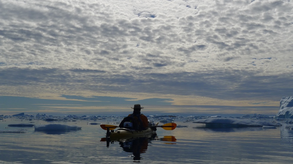
What a day in the ice - the expedition had really started! We had to find our way around the bigger icebergs, pushing away small ice pieces and keeping close together in the moving ice. What an experience for all of us! After some hours in the ice, we came close to the shore line and almost could not believe our eyes - a nice and sandy beach was waiting for us. There was no wind but bright sunshine. After lunch, our mission was to quickly find a good tent spot. After having pushed away some more ice, we succeeded to find a nice tent spot with an amazing view on "Little Reindeer Valley"- and, as it seemed at the beginning, with less mosquitos than we had before. We took a short walk after dinner to a higher point to look at the inlandic ice since it was our plan to hike there the next day. During the night, we had some rain but we were lucky again and it stopped the next morning.
Monday, 9 July 2012
Coordinates:
N74°51´56´´
W057°26´14´´
What a day in the ice - the expedition had really started! We had to find our way around the bigger icebergs, pushing away small ice pieces and keeping close together in the moving ice. What an experience for all of us! After some hours in the ice, we came close to the shore line and almost could not believe our eyes - a nice and sandy beach was waiting for us. There was no wind but bright sunshine. After lunch, our mission was to quickly find a good tent spot. After having pushed away some more ice, we succeeded to find a nice tent spot with an amazing view on "Little Reindeer Valley"- and, as it seemed at the beginning, with less mosquitos than we had before. We took a short walk after dinner to a higher point to look at the inlandic ice since it was our plan to hike there the next day. During the night, we had some rain but we were lucky again and it stopped the next morning.
 |
| Paddling through a lot of ice |
 |
| Pushing away small ice pieces |
 |
| A nice and sandy beach |
 |
| A nice and sandy beach Tent spot with an amazing view on "Little Reindeer Valley" |
Tuesday, 10 July 2012
Coordinates:
N74°54´12´´
W057°13´44´´
In the morning, the rain was gone but it was still cloudy. Nevertheless, we packed our bags with lunch, filled the thermoses and started hiking towards the inlandic ice. On our way there, more and more mosquitos were surrounding us which made us walk fast and straight on to the ice. Once we reached there, the mosquitos were gone and we took our lunch up on the inlandic ice - what a lunch location! After lunch, we decided to take a different path back along the edge of the inlandic ice. The sun came out and it was a beautiful and impressive hike back to the camp site where we enjoyed another dinner in this scenic spot!
 |
| Towards the inlandic ice |
 |
| Towards the inlandic ice On the inlandic ice |
 |
| Picture of the inlandic ice |
 |
| On the way back to our camp site from the inlandic ice |
Wednesday, 11 July 2012
Coordinates:
N74°54´12´´
W057°13´44´´
At 10.45, after breakfast, we took off again with our kayaks - the sun was still shining and it was getting warmer and warmer. We followed the coast line and paddled into the fjord where we had bearded seal following us for a long time - he seemed to be curious to be in as many pictures as possible what we enjoyed a lot! We took lunch at a rocky cliff side before leaving the Greenlandic mainland. We zigzaged ourself between ice floats and huge icebergs towards more open water. We paddled longer than expected because it was such a great paddling day - finally, we came close to two small islands and were welcomed by hundreds of birds, Artic Terns. We found a beautiful tent spot on one of the islands and then it was time to find some small ice blocs to get fresh water. We enjoyed a wonderful evening - with the view on one side towards the inlandic ice and all the icebergs floating around, and on the other side towards the vast Baffin Bay. Just impressive!
 |
| Bearded seal following us for a long time |
 |
|
The bearded seal |
 |
| He seemed to be curious |
 |
| Artic Tern at the bird breeding island |
Thursday, 12 July 2012
Coordinates:
N74°51´37´´
W057°43´24´´
N74°51´37´´
W057°43´24´´
Today, it was time to head south again. We started the sunny morning with a nice breakfast and were all in a very good mood. Over oily waters, we paddled for about 10 kilometers and took our lunch on a cliff. After that, we decided to paddle towards Knud Rasmussen's old hunting hut. Our idea was to camp closely to the hut but there were too many mosquitos. So we kept on for some more kilometers and found a nice bay with a small stony beach where we took up our kayaks for the night. We took a late dinner and put up our tents on a steep and beautiful cliffside.
 |
| Padling along |
 |
| Padling along Iceberg hole with kayaker inside...? |
 |
| Oily waters and a kayak cowboy |
Friday, 13 July 2012
Coordinates:
N74°42´13´´
W057°32´17´´
N74°42´13´´
W057°32´17´´
This was a quick start in the morning - not least due to a considerable number of mosquitos. We left the island behind us to start a long crossing towards Bjorling island. The sun was shining, the water was oily and it could not have been a better day for paddling! At around 4pm, we arrived at the island and had a late lunch and we decided to stay here for the night. It was getting warmer and warmer and we all enjoyed a nice (but cold) swim in the arctic sea. Sadly, the fishing endeavors were not successful - possibly because of all the seals scaring away the fish... Luckily, we still had enough food a nice dinner and enjoyed another beautiful and sunny evening.
 |
| Our solar cell system from HiNation |
 |
| Lunch |
 |
| After lunch nap |
 |
| After lunch nap View from Bjorling island |
Saturday, 14 July 2012
Coordinates:
N74°39´03´´
W057°14´15´´
We got up at around 9am and started the day with a long breakfast - it was as sunny and as warm as it was during the last days and if there had not been all the icebergs around, we could have felt being way further south. We decided to stay another day on the island and started a day trip leaving our tents behind. It was a lot of ice on our way and a dream became true for some expedition members when we climbed on an icefloat. What an experience! We were all in a very good mood and continued towards the mainland where we had our lunch. After lunch, we took on a shorter exploring mission to an island which is very close to the inlandic ice and which had been covered by ice just ten years ago. Not many footprints had been made here before which made us feel like explorers. We then turned around to paddle back to our camp spot. Some more efforts were made to finally catch some fish but it seemed that there were again too many seals around... or was there maybe another explanation...? We still enjoyed dinner and the beautiful location.
 |
| Some expedition members climbed on an icefloat |
 |
| Climbing back in the kayaks afterwards |
 |
| Lunchtime |
 |
| Exploring mission |
Sunday, 15 July 2012
Coordinates:
N74°39´03´´
W057°14´15´´
Immediately, when we woke up, we understood that something had changed - instead of being in bright sunshine, we were surrounded by thick fog. A completely different atmosphere for us and it felt almost mystical. From time to time, icebergs appeared from the fog to immediatly disappear again. We were happy to have two compasses mounted on two of our kayaks and with the help of our GPS's, we found our way through the ice towards Kullorsuaq island. It was very impressive to paddle thourgh the thick fog and not to see the island that we were approaching until we could almost touch it. We then followed the coast line closely and decided to have lunch on a nice cliff. We continued to paddle for a little while before the hut of Kullorsuaq school where we were allowed to stay overnight. The hut was very nice (although not mosquito-proof) and we enjoyed to sit on chairs and cook and eat inside. This evening we tried something new - oily fried seaweed which was so tasty that we jointly decided that this should become a tasty component during upcoming kayak expeditions in the area. At the same time, we all sadly felt that this kayak expedition was soon coming to an end...
 |
| The fog is coming |
 |
| In the fog |
 |
| The school hut near Kullorsuaq |
 |
| Making fried seaweed in the school hut |
Monday, 16 July 2012
Coordinates:
N74°36´00´´
W057°05´29´´
Our last breakfast before coming back to Kullorsuaq - and then it was once again time to get into the water. It was another foggy day but since we only had to follow the shoreline, we could fully enjoy the last kilometers of our expedition. We arrived in the settlement at around 12 o'clock, emptied the kayaks and pulled them out of the water. After 11 days, we were finally back where we started! But while we had all been wondering about what was waiting for us out there when we left, we came now back with many great impressions, knowledge about the area and its possibilities, memories of all the seals and birds that we met on the way - to make it short: a huge number of unforgettable experiences!
Our last task was to prepare the kayaks for the shipping back to Upernavik city and then we once again went to Lars Jensen's place to stay for our last night on Kullorsuaq island. We had dinner with the family and since it was still foggy, we were curious to see if it was actually possible to leave southwards the next day by helicopter...
 |
| The school hut near Kullorsuaq |
 |
| Still some fog on the way |
Tuesday, 17 july 2012
Coodrinates:
N74°34´49´´
W057°09´43´´
W057°09´43´´
What a surprise - at 8 in the morning, the fog had disappeared and some time later it even cleared up in Upernavik. That meant for us to get finally ready for the first trip back south. We left the island at around lunch time and once again enjoyed a beautiful helicopter flight. A perfect ending of our great expedition north of Kullorsuaq, Melville Bay, Greenland!
 |
| The helicopter arrives to Kullorsuaq |
 |
| The helicopter is loading luggage |
 |
| On our way back to Upernavik |
 |
| Our route map for the expedition |
For larger pictures from this blog, look at www.Kayak-North.com
Kayak-North.com
Hav kajak ekspedition til Melvillebugten, nordvest Grønland
Kajak ekspedition til Melvillebugten

Grønlandske fangere fra bygden Kullorsuaq i Upernavik distrikt i nordvest Grøndland tager hver sommer til deres sommer-lejr for at fange få hvaler fra traditionelle grøndlandske kajakker med harpun som de altid har gjort siden tidernes morgen..... Det er den eneste lovlige måde at fange disse narhvaler på i dag. Fangeren bruger alt i hvalen, så intet går til spilde af hvalen.
I 2009 har vi netop en hav kajak ekspedition hvor kajakkeren kan følge jagten fra lejren nord for Kullorsuaq i perioden 2. juli til 28 juli.
Efter at have fulgt fangerne en uges tid går ekspeditionen til Kullorsuaq og videre sydpå til Upernavik, hvor vi undervejs besøger flere små og større bygder. Se hele ruten på denne ekspedition på www. kayak-north.com

Du kan stadig nå at komme med på denne ekspedition, hvis du opfylder vores betingelser for deltagelse i denne ekspedition. Desuden har vi flere ekspeditioner du kan tilmelde dig i Upernavik området i 2009. Se mere info om de foreløbige ekspeditioner i Upernavik distriktet i 2009. Se http://www.kayak-north.com/ for mere info.
Med venlige hilsen
Nikolaj Sørensen
Upernavik, Grønland

Abonner på:
Kommentarer (Atom)